Martin states that the Mongol army would take the same route into Da Xia in 1209 as they did in 1207. The sources I’ve found do not offer an alternative, so in lieu of better evidence I’m happy to go with it. The army saddled up in central Mongolia, travelled south to the Gurban Saikhan Mountain range where they turned south-east. In March of 1209 they crossed Da Xia’s northern border.
The Frontier Zone
This podcast has frequently contained the phrase Frontier Zone, and I’ve described it in vague terms. It is a region which wasn’t quite steppe territory, wasn’t quite settled territory, some groups had been settled in it by various Chinese powers; other groups were more transitory – they moved in and out of it depending on their needs.
In the last decade or so, archaeological work on the Mongolia-Russia-China border, in the far east of Mongolia and in the south of Mongolia has brought some clarity to the subject by confirming the presence of fixed border positions and supporting infrastructure; most excitingly a lot of it has been dated to the Liao, Jin and Tangut periods.
The Tangut Northern Border
Academics have long held the assumption that the Tangut northern border was composed of the mountain ranges and deserts surrounding the state, rather than being a man-made barrier. This has resulted in it being described in vague terms, or just ignored. Until recently, the only evidence we have had of the existence of a fixed medieval boundary between north-western China and Mongolia were notes found in dynastic histories providing locations of Tangut armies and a Qing era copy of a map known in English as the Topographic map of XiXia. These have been used by academics to attempt to identify the location of Tangut administrative and military infrastructure, although little definitive consensus has been reached; The location of Wulahai, for example, is still disputed.
The archaeological investigation of potential Tangut sites in China has provided equally vague and confused results, mostly due to mis-identification and denial of the facts. Chinese academics have arbitrarily attributed sites that present with Tangut era pottery, coins, and medieval carbon dates, to Chinese dynasties – especially the Han; Tangut elements are downplayed, or ignored.
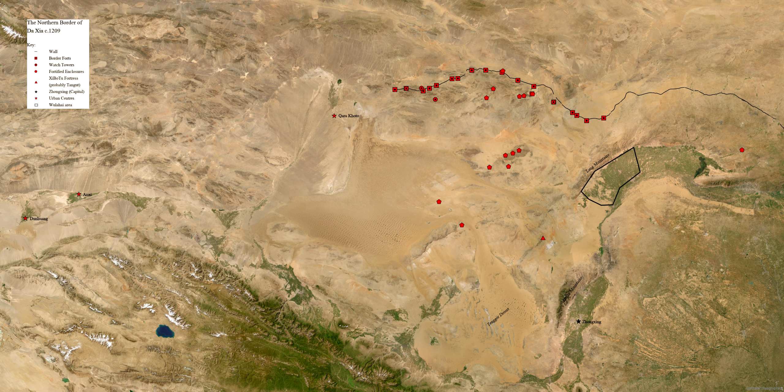
In the last decade this view has shifted helped by archaeological studies such as those led by Alexey Kovalev and Diimaajav Erdenebaatar, by Michael Storozum and by Dan Golan. These three studies have undertaken remote sensing, excavation, survey, fieldwalking, carbon dating and landscape studies to show pretty conclusively that a line of earthworks in the far south of Mongolia, long ago dubbed the Chinggis Khan wall, was almost certainly planned and constructed by Da Xia. This wall stretches for 312km and then crosses into China where it continues for a further 500km, supported by rectangular fort structures and oval observation posts.
And it seems likely that this wall was just the frontline of a complex defensive system established within the Tangut state. Archaeologists have discovered Da Xia era fortifications stretching right across the Alashan, or Alxa, League region in China right up to the modern Mongolian border. The Alxa League is a prefecture level administrative unit of Inner Mongolia, and includes a large part of the Alashan Desert, which is the southwestern, more hospitable part of the Gobi Desert.
These archaeological findings are supported by some of the few Tangut legal texts so far identified and translated. In the 1980s the Russian Orientalist Yevgeniy Kychanov, an expert in Tangut language, published a four-volume translation of the Tangut law code titled the ‘Revised and Newly Endorsed Law Code for the Age of Celestial Prosperity’, and just prior to his death in 2013 he published ‘The New Laws of the Tangut State’. The Revised and Newly Endorsed Law Code was compiled between 1149 and 1169, during the 54-year reign of Renzong, whilst the New Laws were potentially added as a reaction to the Mongol conquest of 1209. Both texts were translated from Tangut into Russian, and there are partial Chinese translations. English-language translations of the relevant parts related to border defence can be found in the three studies mentioned above.
Archaeology of the Northern Wall
The preserved wall in Mongolia is a standardised design across the full 300km. It was roughly 3m wide and constructed of earth, wood and stone, depending on the availability of the local resources. It optimised these resources to maximise structural integrity; the external, Mongolia, facing wall is often clad in stone to protect against erosion and attack, whilst the internal face was braced with wooden supports that prevented slumping and collapse. These wooden supports may have supported an upper wall section, but no wall top survives to confirm this – the wall is preserved to a maximum height of 2.6m.
The wall is supported by 13 rectangular garrison structures all of which are on the Tangut side of the wall and lie almost directly on it. These structures have perimeter walls which are preserved to a maximum height of 2.5m and like the border wall are constructed of a mix of earth, stone and wood. Tools found in these sites suggest that the Tangut used the rammed earth construction method which was widely utilised across China. There was no evidence within these sites of fixed garrison dwellings, but hearths and middens containing a high level of animal bone and charcoal have been discovered. Tangut pottery found on these sites are of a design typical of two large Tangut kilns located some 500km from the northern border; Coins, projectile points, architectural fasteners, fragmented wheel hubs and domestic implements were also found during excavations. Carbon dating of wood and charcoal from these structures and the wall have returned 11th century construction dates, tying in with the expansion of Da Xia by Yuanhao and his successors.
Other frontline structures include mountain pass forts and forts covering strategic points. These were typically much simpler structures than the garrisons and returned far fewer artefacts. As their names suggest, these structures covered areas of strategic weakness or high points, sometimes beyond the wall, to provide visual coverage of the region.
Set back from this front line were garrison forts, watch towers and a structure described by Kovalev and Erdenebaatar as a fortified settlement. This type of fort used dry-stone walls to enclose a significant area of land, typically a whole valley, which the authors suggest enabled the Tangut to store livestock during times of trouble. I have labelled these as fortified enclosures. Dawulan is the largest enclosure so far identified by studies.
For more detailed analysis see Dan Golan’s article, Exploring the Gobi Wall: Archaeology of a Large-Scale Medieval Frontier System in the Mongolian Desert, in the journal Land 14. It does a particularly good job of bringing the archaeological data together with the translated Tangut law codes to present Da Xia as an extremely complex, dynamic society, rather than the somewhat generic footnote we see in many accounts of the state.